
 We now have mapping apps capable of turn-by-turn directions, up-to-the-minute traffic, and even crowdsourced updates, along with machine learning models that can determine the fastest way to get from point A to point B.
The advantage of these navigation apps is that they can use a smartphone’s GPS receiver, along with 4G-LTE data to get faster and more accurate location information.
Google Maps has been one of the oldest and most comprehensive solutions, having mapped almost every corner of the world. They have even mapped the interiors of airports and buildings. You can access Google Maps as a standalone app, or as a component of Android Auto, which can be found in the latest car models or launched as a standalone app.
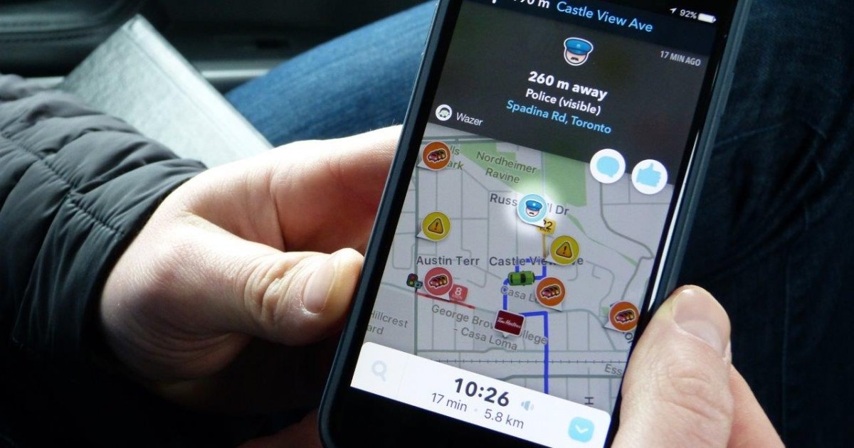
Waze has been another popular app. Similarly cross-platform like Google Maps, it has the added advantage of also being a social network. Waze members can contribute real-time traffic status and alert other users to the presence of police, potholes, accidents and construction situations that could delay your trip.
Waze has also teamed up with various cities to derive real-time traffic information from government offices tracking the situation. This allows Waze to suggest the best alternative routes for users to take. Part of Waze’s social aspect is that you can also see which of your friends are on the road. ‘Honk’ at them to say hi, sort of how some people used to poke each other on Facebook.
I’ve used both solutions extensively through the years in Canada and overseas. Here are my findings.
Waze
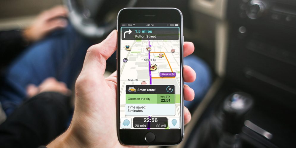
Waze appears to be the more innovative of the two. It can easily replace a standalone GPS device, and has some fun features, too. Choosing from a variety of navigator voices, altering the look of the map to suit your preference and having real-time traffic information are all key to resolving driving delays.
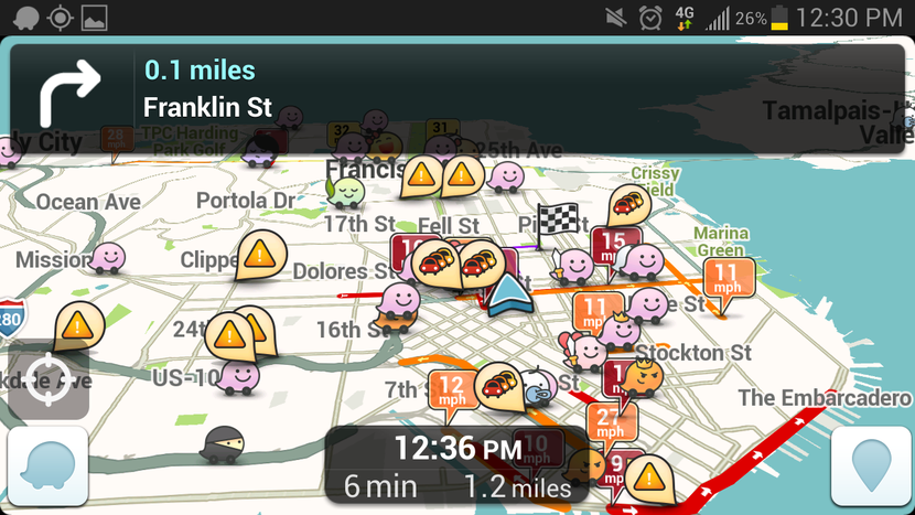
Waze seems to be the better navigation app for getting the most information for your trip. It will tell you when there’s construction ahead, where police speed traps are spotted, when debris is on the road and when cars are stalled. You can give back to the community by quickly confirming that these situations are still going on when you pass by. Doing that earns you community points and an opportunity to level up to earn new avatars.
As a navigation tool, Waze was accurate and flexible most of the times I used it. I like that it gives directions way ahead and repeats them frequently enough, so drivers can be prepared to take a big turn or get to the correct exit on time.
Except Waze’s directions aren’t always the most intuitive. It may try to help you avoid traffic by sending you through a residential area, but while there’s less traffic in that direction, you could be forced to drive slower because of frequent stops at stop signs and intersections. That could require more effort and be more stressful when driving.
I also find Waze is too busy, visually. Ads constantly pop up for random restaurants and nearby stops, which are irrelevant and distracting. The map is littered with logos of famous restaurants and hotels, who are clearly paid advertisers. Also, seeing your Facebook friends using Waze in other countries isn’t helpful or necessary when looking at a cramped screen.
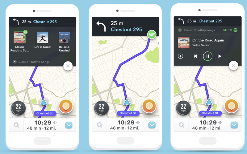
On the other hand, one of Waze’s coolest features is how it integrates seamlessly with Spotify, allowing you to access the streaming service’s songs and music playlists within the Waze screen. All told, Waze is a good service at its core. I would even pay for it, provided I can remove all the peripheral distractions.
Google Maps
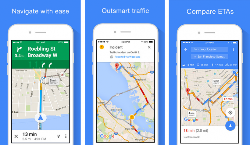
Google Maps is a far cleaner and more straightforward solution. You can use voice or even preset destinations from a web app before you even get to your car. Google Maps also has decent real-time traffic information and can calculate and present various alternative routes (i.e. this route is 5 minutes faster, want to take it?)
I would say Google Maps is on par with Waze in city traffic, sometimes offering more sensible routes and alternatives. I also value the ability to download city maps for offline use. This makes Google Maps the only option when driving in a foreign country without racking up steep roaming data bills.
Google Maps has also become more generalized as a navigation and location app. The latest version on Android shows nearby locations for food and entertainment. It has curated local content that reads more like a magazine. All that goes away when you engage the driving mode.
My biggest issue with Google Maps—and the reason I revert exclusively to Waze during highway driving—is the latency and lack of persistent updates during highway driving.
I’ve experienced missing an exit because the voice alert came too late for me to safely navigate the exit, adding more time to my trip and requiring me to find another route back to that part of the route.
I also find that Google Maps gets confused more often than Waze. Maybe due to poor a GPS signal or busy cloud processing times, there are instances where Google Maps seems lost, leaving me in the lurch.
Wrap Up
Waze and Google Maps have their respective strengths depending on what you need. If you are mostly driving in the city, both will work accurately. Waze just has an additional advantage of real-time feedback from other users.
Google Maps is similarly adept at navigating, and many will prefer the voice control through Google Assistant, plus the lack of pop-up windows and obvious advertising. For highway driving, Waze has the advantage in speed and timing, especially for more challenging intersections and highway exits.
Since everyone’s navigation needs are different, I suggest trying out both apps since they are free. Give each a chance and decide which system and interface works best for you. They work on both iOS and Android smartphones, providing you real flexibility in how you use while cruising the road.


